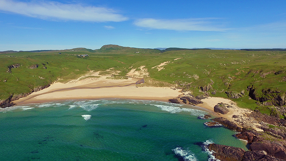
 An aerial view of Lossit Bay on the west coast of the Rhinns of Islay, taken from a drone flying high above the Atlantic. In the distance Beinn Tart a’Mhill, at 232m the highest hill on the Rhinns.
Islay Pictures Photoblog
Pictures from the Isle of Islay, Scotland

tag:facebook.com,2013:10155925711568268_liked_by_10206572828507868
Graham Paterson
https://www.facebook.com/776938267/posts/10155925711568268#liked-by-10206572828507868
tag:facebook.com,2013:10155925711568268_liked_by_10151957429526901
Enrico Anders
https://www.facebook.com/776938267/posts/10155925711568268#liked-by-10151957429526901
tag:plus.google.com,2013:z13qvzrrqtb0tl120224jdxpoveau1njn04_liked_by_117129681268939588976
Dan Weese
https://plus.google.com/+ArminGrewe/posts/BiCUZWrdt2x#liked-by-117129681268939588976
tag:facebook.com,2013:10155925711568268_liked_by_10203662943153794
Imke Grewe
https://www.facebook.com/776938267/posts/10155925711568268#liked-by-10203662943153794
tag:facebook.com,2013:10155925711568268_liked_by_871495486281108
Andrew Treppass
https://www.facebook.com/776938267/posts/10155925711568268#liked-by-871495486281108
tag:facebook.com,2013:10155925711568268_liked_by_737562809598847
Pali Fukatsch
https://www.facebook.com/776938267/posts/10155925711568268#liked-by-737562809598847
tag:twitter.com,2013:894428040943607808_favorited_by_297860499
Heppie Hepster
heppiehepster
https://twitter.com/islayblog/status/894428040943607808#favorited-by-297860499
tag:facebook.com,2013:10155925711568268_liked_by_906470646038737
Stephan Goldmann
https://www.facebook.com/776938267/posts/10155925711568268#liked-by-906470646038737
tag:plus.google.com,2013:z13qvzrrqtb0tl120224jdxpoveau1njn04_liked_by_107608481593819387523
Éric Mac Lewis
https://plus.google.com/+ArminGrewe/posts/BiCUZWrdt2x#liked-by-107608481593819387523
tag:twitter.com,2013:894428040943607808_favorited_by_18491498
Avallonian
Avallonian
https://twitter.com/islayblog/status/894428040943607808#favorited-by-18491498
tag:facebook.com,2013:10155925711568268_liked_by_10152784848439202
Leon Murphy
https://www.facebook.com/776938267/posts/10155925711568268#liked-by-10152784848439202
tag:facebook.com,2013:10155925711568268_liked_by_993297837348574
Finlay Macintyre
https://www.facebook.com/776938267/posts/10155925711568268#liked-by-993297837348574
tag:facebook.com,2013:10155925711568268_liked_by_10154104817347195
Triker Snoops
https://www.facebook.com/776938267/posts/10155925711568268#liked-by-10154104817347195
tag:facebook.com,2013:10155925711568268_liked_by_492049207610125
Andrew Greenwood
https://www.facebook.com/776938267/posts/10155925711568268#liked-by-492049207610125
tag:facebook.com,2013:10155925711568268_liked_by_806032549432284
Seonaid Wilson
https://www.facebook.com/776938267/posts/10155925711568268#liked-by-806032549432284
tag:twitter.com,2013:894428040943607808_favorited_by_268727360
Nicola Spurgeon
Spudnic1968
https://twitter.com/islayblog/status/894428040943607808#favorited-by-268727360
tag:facebook.com,2013:10155925711568268_liked_by_718241468235100
Klaas Steenhuis
https://www.facebook.com/776938267/posts/10155925711568268#liked-by-718241468235100
tag:facebook.com,2013:10155925711568268_liked_by_10205190266731159
Peat Smoke
https://www.facebook.com/776938267/posts/10155925711568268#liked-by-10205190266731159
tag:twitter.com,2013:894428040943607808_favorited_by_874764055931760640
Eona Graham
GrahamEona
https://twitter.com/islayblog/status/894428040943607808#favorited-by-874764055931760640
tag:twitter.com,2013:894428040943607808_favorited_by_2609886324
Paul Jones
pjcopywriting
https://twitter.com/islayblog/status/894428040943607808#favorited-by-2609886324
tag:plus.google.com,2013:z13qvzrrqtb0tl120224jdxpoveau1njn04_liked_by_109168522695182815419
William Pew
https://plus.google.com/+ArminGrewe/posts/BiCUZWrdt2x#liked-by-109168522695182815419
Good morning with a picture of Lossit Bay and Beinn Tart a’Mhill from the air, Isle of Islay islay.org.uk/2017/08/07/los…
tag:facebook.com,2013:10155925711568268_liked_by_800738249974829
Janette MacArthur
https://www.facebook.com/776938267/posts/10155925711568268#liked-by-800738249974829
tag:twitter.com,2013:894428040943607808_favorited_by_144643097
Snoops Taylor
SnoopsX111
https://twitter.com/islayblog/status/894428040943607808#favorited-by-144643097
tag:twitter.com,2013:894428040943607808_favorited_by_426023603
MusikausStrom
MHFFMNN
https://twitter.com/islayblog/status/894428040943607808#favorited-by-426023603
Good morning with a picture of Lossit Bay and Beinn Tart a’Mhill from the air, Isle of Islay islay.org.uk/2017/08/07/los…
tag:twitter.com,2013:894428040943607808_favorited_by_80550982
shauna coles
scoles10
https://twitter.com/islayblog/status/894428040943607808#favorited-by-80550982
tag:twitter.com,2013:894428040943607808_favorited_by_496419859
Donald Stewart
MacDomhnall
https://twitter.com/islayblog/status/894428040943607808#favorited-by-496419859
tag:facebook.com,2013:10155925711568268_liked_by_1613346445614425
Jane Ashall
https://www.facebook.com/776938267/posts/10155925711568268#liked-by-1613346445614425
tag:twitter.com,2013:894428040943607808_favorited_by_829109650763177984
Andra McCarmaig
Bunothanboy
https://twitter.com/islayblog/status/894428040943607808#favorited-by-829109650763177984
tag:facebook.com,2013:10155925711568268_liked_by_578478225633804
Iain Macarthur
https://www.facebook.com/776938267/posts/10155925711568268#liked-by-578478225633804
tag:facebook.com,2013:10155925711568268_liked_by_806897486034098
Andy Buttery
https://www.facebook.com/776938267/posts/10155925711568268#liked-by-806897486034098
tag:facebook.com,2013:10155925711568268_liked_by_10205111619123154
Janet Waterworth
https://www.facebook.com/776938267/posts/10155925711568268#liked-by-10205111619123154
tag:twitter.com,2013:894428040943607808_favorited_by_298162918
CathrynMcQuaig-Smith
Xingu1882
https://twitter.com/islayblog/status/894428040943607808#favorited-by-298162918
tag:facebook.com,2013:10155925711568268_liked_by_854431187999322
Etta Shaw
https://www.facebook.com/776938267/posts/10155925711568268#liked-by-854431187999322
tag:facebook.com,2013:10155925711568268_liked_by_1285457748135174
Douglas Hay
https://www.facebook.com/776938267/posts/10155925711568268#liked-by-1285457748135174
tag:facebook.com,2013:10155925711568268_liked_by_10201875847673538
Gernot Hoffmann
https://www.facebook.com/776938267/posts/10155925711568268#liked-by-10201875847673538
tag:facebook.com,2013:10155925711568268_liked_by_1732606663446211
John Hyde
https://www.facebook.com/776938267/posts/10155925711568268#liked-by-1732606663446211
tag:facebook.com,2013:10155925711568268_liked_by_10153114294955496
Gráinne Nic Bhrádaigh
https://www.facebook.com/776938267/posts/10155925711568268#liked-by-10153114294955496
tag:facebook.com,2013:10155925711568268_liked_by_656880367776259
Robert Davison
https://www.facebook.com/776938267/posts/10155925711568268#liked-by-656880367776259
tag:facebook.com,2013:10155925711568268_liked_by_1836903853224361
Christine Bailey
https://www.facebook.com/776938267/posts/10155925711568268#liked-by-1836903853224361
tag:facebook.com,2013:10155925711568268_liked_by_10153840293425031
Angus MacKinnon
https://www.facebook.com/776938267/posts/10155925711568268#liked-by-10153840293425031
tag:facebook.com,2013:10155925711568268_liked_by_211292015983444
Margaret MacKinnon
https://www.facebook.com/776938267/posts/10155925711568268#liked-by-211292015983444
Lossit Bay and Beinn Tart a’Mhill from the air (2), Isle of IslayA slightly different version of the view of Lossit Bay and Beinn Tart a’Mhill from the air. Taken with a DJI Phantom 3 drone back in June 2015. Which version do you prefer?
Share this picture:EmailWhatsAppTwitterFacebookPinterestTumblrLinkedInReddit
You might also like these pictures: