
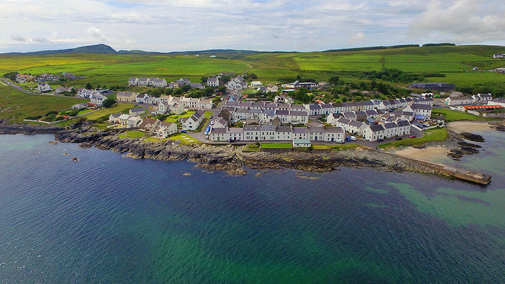
A drone view of Port Charlotte on the Rhinns of Islay at the shore of Loch Indaal. The view stretches from Port Charlotte West End on the left to the old Lochindaal distillery (now home to the Youth Hostel and the Islay Natural History Trust) on the right. Shore Street in the foreground (obviously) with Rhu to the left. Main Street (which is also the A847) the next one up, stretching all the way through the view. School Street going up from the junction of Shore Street and Rhu to the top of the village left of centre. And Beinn Tart a’Mhill, the highest hill on the Rhinns of Islay, in the distance on the left.
This Image was mentioned on brid.gy
This Image was mentioned on brid.gy
This Image was mentioned on brid.gy
This Image was mentioned on brid.gy
This Image was mentioned on brid.gy
This Image was mentioned on brid.gy
This Image was mentioned on brid.gy
Wow – never seen it from that angle before!
Good morning with a picture of Port Charlotte at Loch Indaal from the air, Isle of Islay islay.org.uk/2021/05/28/por…
This Image was mentioned on brid.gy
This Image was mentioned on brid.gy
This Image was mentioned on brid.gy
This Image was mentioned on brid.gy
Good morning with a picture of Port Charlotte at Loch Indaal from the air, Isle of Islay islay.org.uk/2021/05/28/por…
This Image was mentioned on brid.gy
My family and I should be there. Had to cancel ‘cos of Glasgow lockdown. Still gutted, so I devour your pics. Love this one.
This Image was mentioned on brid.gy
This Image was mentioned on brid.gy
This Image was mentioned on brid.gy
This Image was mentioned on brid.gy
This Image was mentioned on brid.gy
This Image was mentioned on brid.gy
This Image was mentioned on brid.gy
This Image was mentioned on brid.gy
This Image was mentioned on brid.gy
that’s fantastic
wonderful picture of my lovely village…and our house is right there #islay #whiskyisle #lovewhereyoulive #home
This Image was mentioned on brid.gy
This Image was mentioned on brid.gy
This Image was mentioned on brid.gy
This Image was mentioned on brid.gy
This Image was mentioned on brid.gy
Good morning with a picture of Port Charlotte at Loch Indaal from the air, Isle of Islay islay.org.uk/2021/05/28/por…
This Image was mentioned on brid.gy
This Image was mentioned on brid.gy
This Image was mentioned on brid.gy
This Image was mentioned on brid.gy